
How to find old maps of France online
Google maps and Google streetview are very helpful to discover what your ancestors’ hometown looks like nowadays. But most of the time, landscapes and towns have changed a lot over the last century.
Fortunately, there are many ways to find old maps to better understand the environment in which your French ancestors lived, and to discover:
- the exact location of a hamlet ;
- where were the forests and rivers;
- where were the main roads;
- what changes have happened in your ancestors’ hometown.
Here are some examples of how you can find old maps of France, cadastral maps and city maps, online.
Old maps of France
On Gallica, you can find old maps of France or of French regions from almost any time since the 16th century. To find maps on Gallica, select « maps » next to the search field and then type the name of the region you are interested in (see this other post for more information on how to use Gallica).
Although the most ancient maps are not very precise, they can be helpful to find out which were the most important cities and to know to which administrative subdivision your ancestors’ hometown belonged to.
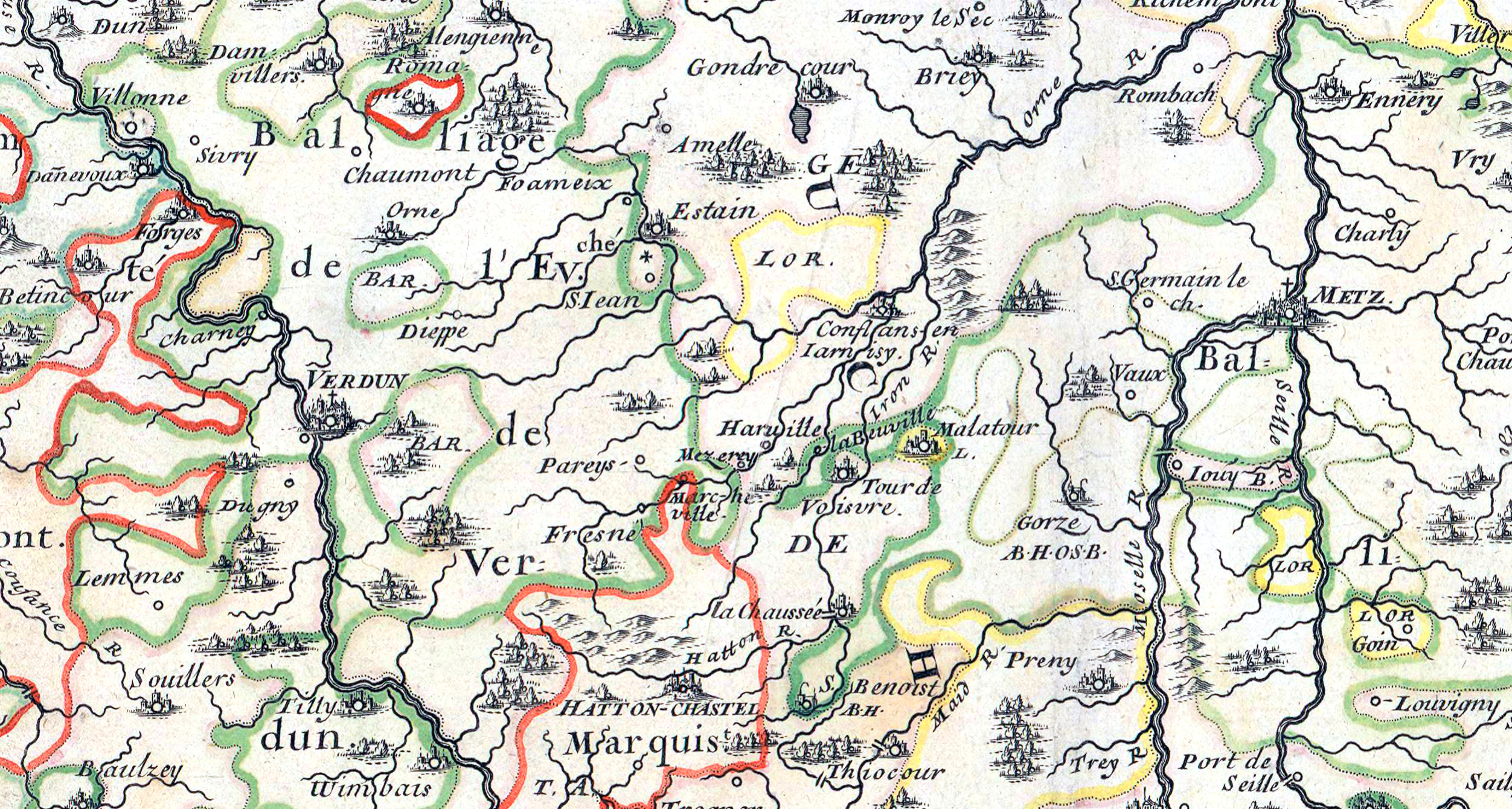
The first topographic and geometric map of the Kingdom of France was established in the 18th century. It is called the Cassini map (“carte de Cassini“) as it was compiled by different members of the Cassini family. This map is extremely precise, as it was made by precise measurements, and it shows every French town, even the small hamlets.
The Cassini map can be found through different websites:
- on Gallica (as explained in this other post : How to use Gallica to know your French ancestors) ;
- on Geoportail, where you can find it by clicking on “Cartes” on the top left corner, then on “Voir tous les fonds de carte” and by selecting “Carte de Cassini“.
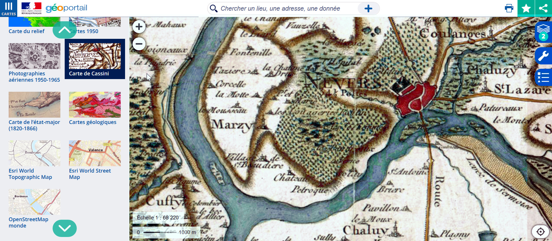
On the Geoportail website, you can also find another interesting map: “la carte de l’état-major“. It is a survey map that was created by the military in the 19th century. Like the Cassini map, it is very precise and covers the whole territory of France.
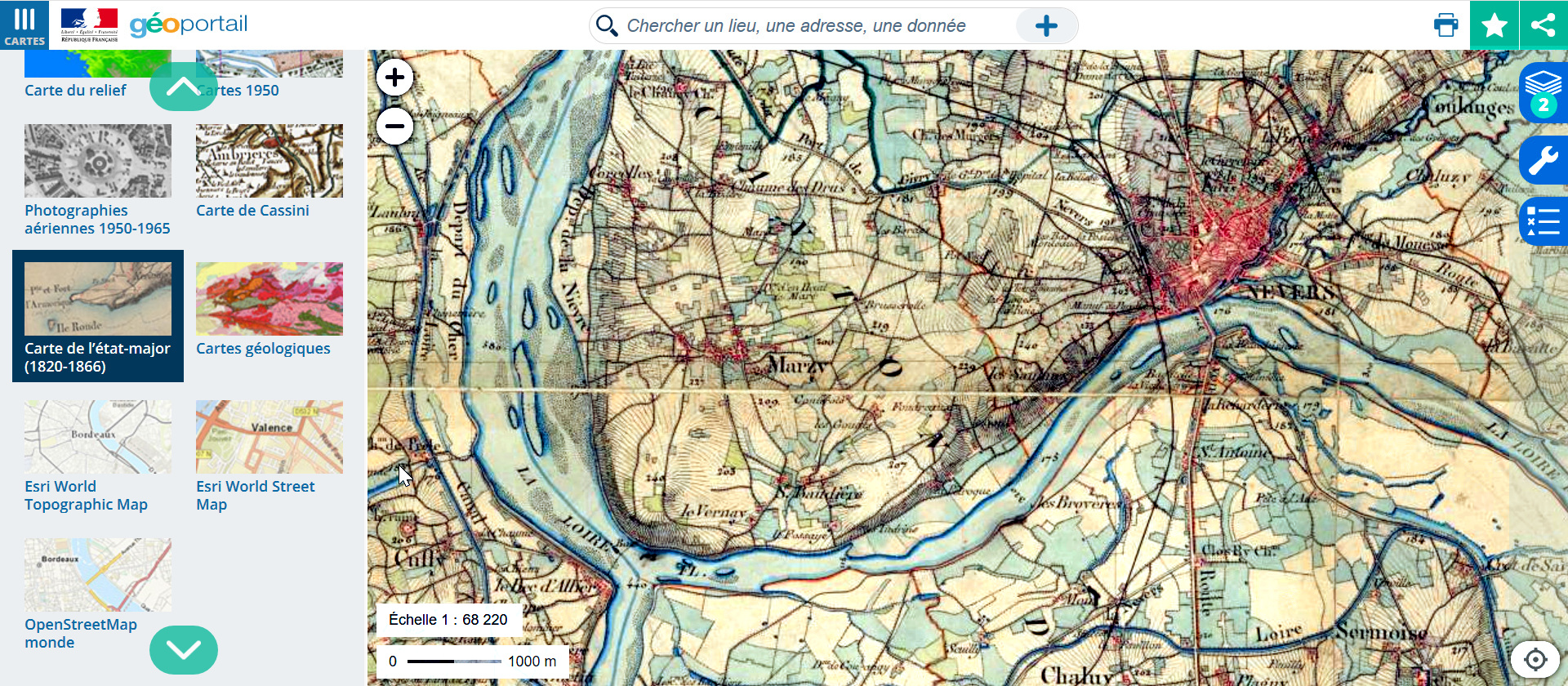
The main asset of the Geoportail website is that you can use layers to compare the old maps with the most recent maps, or with aerial views (recent or from the 1950s).
Cadastral maps
Cadastral maps (“plans cadastraux“) are very helpful to find precise maps of any French town or village from the 19th century.
The main cadastral maps were created in the 19th century when Napoleon decided to establish precise cadastral maps of all towns, in order to control and standardize property taxes across France. This is why these maps are usually called “cadastre napoléonien“.
These cadastral maps have usually been digitized and can be found on the websites of the departemental archives.
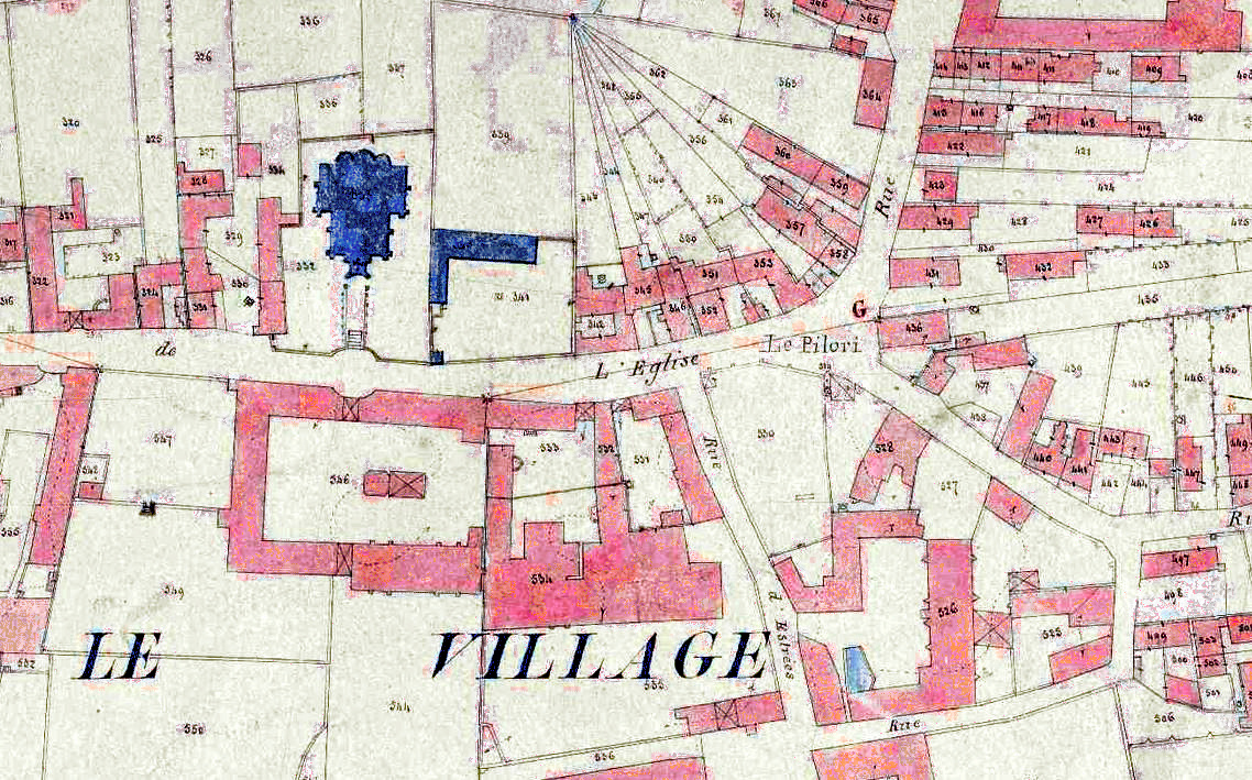
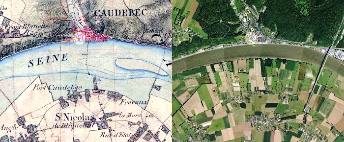
These maps show the delimitations of every piece of land, and they are particularly helpful to find the exact location of your ancestors’ houses (if you have found the reference of the plots that they owned).
However, even if you do not know the reference of your ancestors’ plots, cadastral maps can be useful to discover more precisely what their hometown looked like.
For example, by comparing the 19th cadastral map to a recent cadastral map, I discovered that the church of my grandparents’ village was demolished in the end of the 19th century and rebuilt at another location.
City maps
If your ancestors lived in a city, their address will usually be mentioned in civil registration. Thus, thanks to cadastral maps or city maps, you will be able to locate their street. This is particularly helpful for streets that have disappeared or have been renamed nowadays.
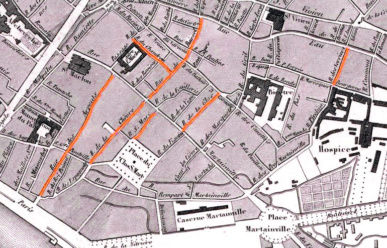
You can find a great number of city maps from different time periods on Gallica (see this other post for more information on how to use Gallica).
For example, thanks to an old map of the city of Rouen, I was able to locate all the streets where my ancestors lived in the 19th century. Most of these streets do not exist anymore due to the numerous changes that happened in Rouen since that time:
- some parts of the city, which were mostly slums, were cleaned up in the end of the 19th century;
- some small streets were demolished to make room for larger streets or squares;
- some districts where destroyed by bombings during the Second World War.
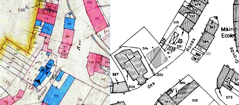
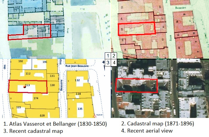
For important cities, like Paris or Lyon, different cadastral maps were established during the 19th and 20th century. Thanks to these maps, we can see the evolution of the streets and buildings where our ancestors lived.
These cadastral maps (“plans parcellaires“) can usually be found on the website of the city archives:
- For Paris, cadastral maps before and after 1860 can be found on this page;
- For Lyon, you can find cadastral maps from 1861 to 1983 on this page.
For example, thanks to the cadastral maps of Paris, I was able to see the evolution of the building where my great-grandmother lived as a child. We can see that her building changed between maps 1 and 2 (so between 1850 and 1870), and that it is still the building that is standing nowadays.


These maps are very interesting… thank you. Unfortunately my research has been halted before it starts, precisely because we don’t have a place of birth for my 3x ggf was Jean Adam Mager, b. 1783 (Alsace-Lorraine) d. 1861 (Canada).
We understand that Adam’s father regularly drove stage coach between Strasbourg and Paris.
I’ve searched for any records that might document any aspect of this journey… the roads travelled, any way-stations, to no avail. Any suggestions would be welcome.
Hello,
on Gallica, you can find maps of the roads and way stations that existed in the 18th century: this network was called “Poste aux Chevaux” or simply “Postes” and the way stations were called “Relais de poste”.
If you look for maps with the keyword “Postes” on Gallica, you will find many maps which can show you the roads he would have taken and the way stations where he might have stopped to change his horses / sleep / etc.
For example, this map from 1784: https://gallica.bnf.fr/ark:/12148/btv1b84407277/f1.item.zoom
Or this map from 1751: https://gallica.bnf.fr/ark:/12148/btv1b53099698p/f1.item.zoom
Elise
How can the old cadastral maps of Mahe I.e. a union territory of Pondicherry be found in the french department archives. Kindly help with an email yo
manithebluepearl@gmail.com
Thanks.
Kindly note that Mahe is an erstwhile French colony in India and the power was transferred to India after her independence in the 1950s. Many French citizens and their descendants still live in Mahe.
Hello,
I unfortunately do not know precisely where these archives can be found. The most likely would be to look for them in the “Archives Nationales d’Outre Mer” (ANOM) where documents concerning the French colonial empire are kept.
Best regards,
Elise